Research
Past and ongoing research themes in the lab
Statistical advances in forest modeling
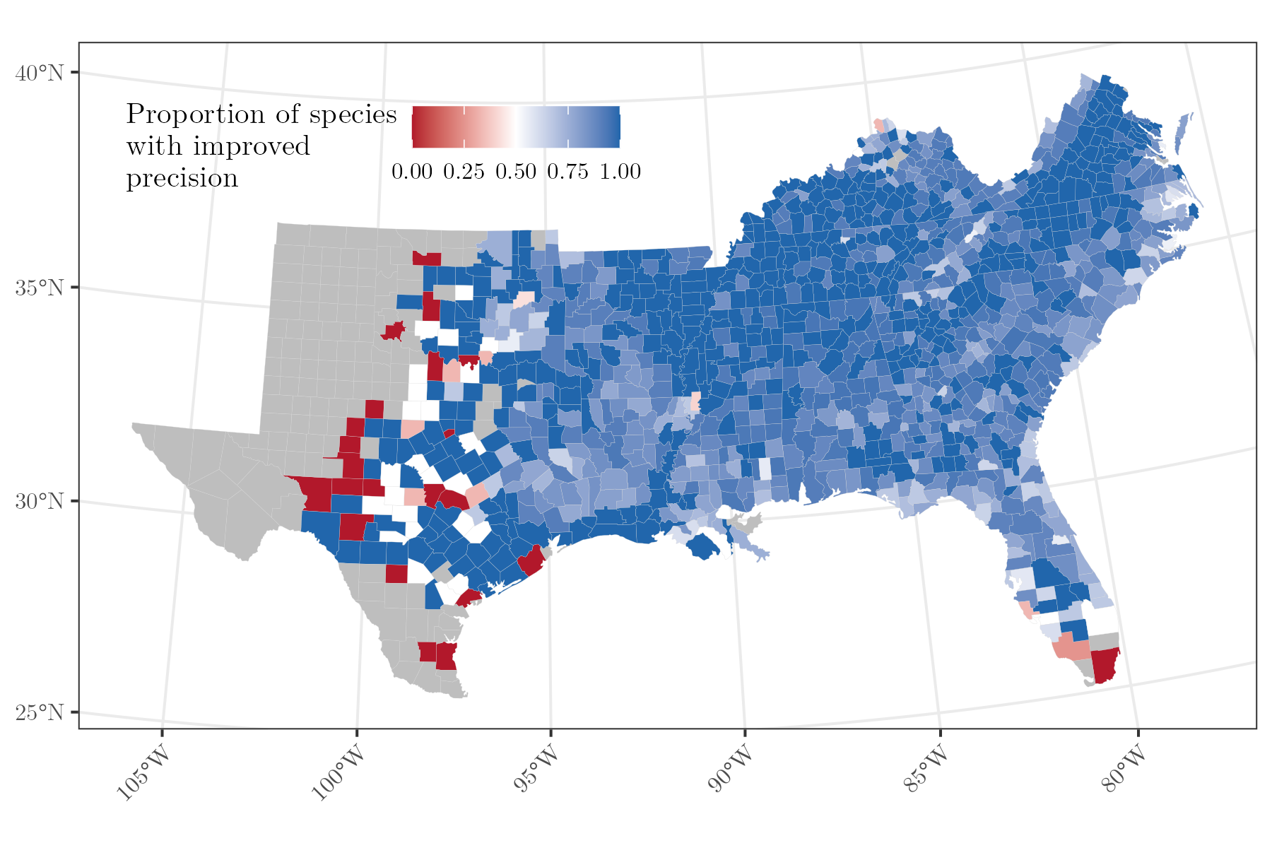
Forest management and production increasingly require estimates of forest variables at fine spatial resolutions. National Forest Inventory (NFI) data provide a robust resource to inform local management objectives, yet classical approaches are not well-suited to do so. We develop advanced statistical frameworks for leveraging NFI data to provide insights on forest parameters at management-relevant scales.
We developed a multivariate spatial Bayesian model to generate more precise estimates of forest parameters by species or species groups. We applied our approach for estimating county-level biomass across the U.S. Southeast for the 20 most common species in the region (Doser et al. 2025 Forest Ecology and Management).
Active projects in the lab include building spatially-explicit height diameter models using Forest Inventory and Analysis data and incorporating the Forest Vegetation Simulator within a Bayesian framework for generating stochastic estimates of growth and yield.
Natural resources software development
Effective forest and wildlife management requires user-friendly software that makes state-of-the-art statistical tools accessible to natural resource managers, foresters, wildlife professionals, and conservation practitioners. A key pillar of the lab's research is developing computationally-efficient and accessible software to inform natural resource management and conservation.
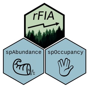
I am the lead author and maintainer of the spOccupancy R package, which fits spatially explicit single-species, multi-species, and integrated Bayesian occupancy models (Doser et al. 2022 MEE), with an emphasis on making these complex statistical models accessible to ecologists, managers, and conservation practitioners that may lack extensive training in spatial statistics. With collaborators across the world, I am actively using spOccupancy to inform effective conservation and management approaches for birds, mammals, trees, bats, crickets, invasive aquatic plants, and cartilaginous fish. For example, with collaborators at the University of Arkansas, we used spOccupancy within a scenario planning framework to understand the effects of multiple woodland restoration outcomes on bird communities in Arkansas, USA (Roberts et al. 2024 Restoration Ecology).
I am also the lead author and maintainer of the R package
spAbundance that provides
user-friendly approaches to efficiently fit spatially explicit single-species (i.e., univariate)
and multi-species (i.e., multivariate) abundance-based generalized linear models, N-mixture
models, and distance sampling models
(Doser et al. 2024 MEE). spAbundance allows for robust
modeling of multi-species abundance patterns, providing crucial insight into the patterns that
determine population dynamics and ecological communities. We used spAbundance to
explore trends in butterfly communities across the midwestern US
(Leuenberger et al. 2025),
pollinator communities in Maryland, US
(Quinlan et al. 2025),
and American chestnut restoration across the eastern US (Fertakos et al. In review).
In 2024, I took over as the lead developer and maintainer of the rFIA R package, which increases the accessibility and use of the USFS Forest Inventory and Analysis (FIA) Database by providing a user-friendly, open-source platform to easily query and analyze FIA data. Future projects in the SEFS Lab include building model-based estimators into rFIA for estimating forest carbon at user-defined spatial scales.
I contributed to the R package ForestFit, which is designed to streamline estimation of common probability distributions used to model tree diameter distributions, including two and three parameter Weibull distributions, Johnson's SB distribution, Birnbaum-Saunders distribution, and finite mixture distributions in both a frequentist and Bayesian approach.
Using autonomous monitoring systems to inform forest and wildlife management
Autonomous monitoring systems such as LiDAR, acoustic recording units, camera traps, and other remote sensing methods can provide massive amounts of data to inform forest and wildlife management, yet analyzing these data presents novel computational complexities. We develop quantitative approaches to leverage these complex data to inform a variety of forest and wildlife management objectives.
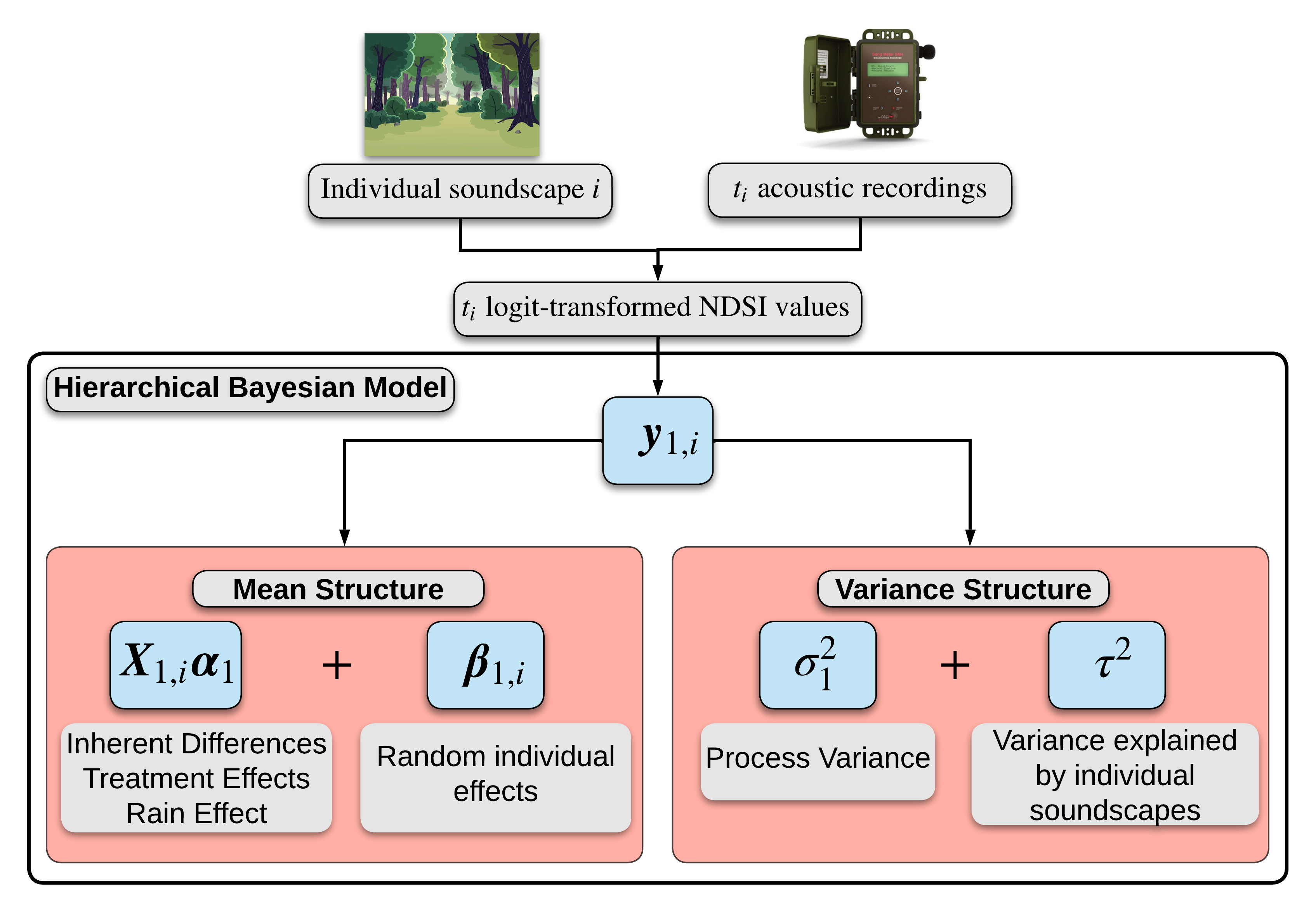
A key focus in the Statistical Ecology and Forest Science lab is developing the statistical tools needed to integrate emerging technologies into existing analysis workflows to inform management objectives. Much of our work focuses on using acoustic recording units to improve insights on ecological communities. We developed hierarchical Bayesian models that leveraged acoustic recording data to understand relationships between anthropogenic noise and biological sounds in avian soundscapes (Doser et al. 2020, Landscape Ecology) and the effects of a shelterwood logging on avian soundscapes in northern Michigan (Doser et al. 2020 Ecological Indicators). Additionally, we integrated automated acoustic data, machine learning algorithms, and point count survey data in a hierarchical modeling framework to estimate bird abundance (Doser et al. 2021 MEE), which can serve as a cost-effective approach to understand spatial patterns in abundance of acoustically active species. With colleagues at the University of Montana and the National Park Service, we used automated acoustic data to inform management of Clark's Nutcracker in relation to declining Whitebark pine trees in the western US (Kovalenko et al. 2024 Ecology and Evolution).
Future work in the Statistical Ecology and Forest Science Lab will continue to build automated workflows for the statistical analysis of acoustic data, with a particular emphasis on accounting for false positives and mis-identifications in acoustic data. Additionally, we seek to build upon existing methodological frameworks to improve the fusion of traditional forest inventory data with new remote sensing technologies like LiDAR.
Developing statistical models to understand ecological processes across macroscales

Understanding the drivers of species distributions, forest resources, and biodiversity at macroscales is complicated by a variety of ecological and observational complexities, such as spatial autocorrelation, nonstationarity in species-environment relationships, and species interactions. In the Statistical Ecology and Forest Science Lab, we account for these complexities to provide a more complete understanding of macroscale ecological processes and inform effective monitoring and conservation approaches across spatial scales.
Previous and ongoing work in the lab has focused on both model development and applications of such models to inform management and conservation objectives for birds, forests, butterflies, anurans, and bats. With collaborators at the National Park Service, we built a community abundance model that accounted for imperfect detection to understand forest bird abundance trends of >100 species across a network of protected forests in the Northeastern US (Doser et al. 2021 Ecological Applications), which revealed abundance trends were heterogeneous across space but consistent among species within a protected area. Recognizing the increased proliferation of publicly available data sources, we developed an integrated community occupancy model that fuses multiple detection-nondetection data sources within a single statistical model to improve our ability to estimate species and biodiversity dynamics (Doser et al. 2022 Methods in Ecology and Evolution).
Modeling across macroscales increasingly requires spatially-explicit approaches that can leverage the spatial distribution of data points to improve model predictive performance. We developed a joint species distribution model that accounts for spatial autocorrelation, imperfect detection, and species correlations to yield more accurate estimates of species distributions and biodiversity (Doser, Finley, Banerjee 2023 Ecology). We have also developed new methodological approaches to estimate spatially-varying (or nonstationary) species-environment relationships (Doser et al. 2024 JABES), as well as practical guidelines and recommendations for the use of these models in ecology and conservation (Doser et al. 2024 GEB). In collaboration with the Minnesota Department of Natural Resources, we are extending this framework to estimate spatially-varying, nonlinear trends in a community of anurans across Minnesota, showcasing the potential of spatially-varying trend models to inform coordinated, multi-scale management action plans.
We are currently working on a variety of projects in which we are leveraging spatially-explicit modeling approaches to understand ecological processes across macroscales. With collaborators across Europe and Michigan State University, we are leveraging a multi-species spatially-explicit abundance framework to quantify trends in Middle Eastern butterfly communities over the last 15 years. With collaborators at MSU, the National Audubon Society, and the National Park Service, we are estimating the relative importance of climate and land-use change in driving occupancy trends on over 300 bird species across the continental US over the last 20 years, which will provide important insights on where and what kinds of conservation actions will have the most impact on bird communities. With collaborators at the US Forest Service and University of Massachusetts Amherst, we are quantifying the effects of vapor pressure deficit and growing season precipitation on species-specific forest biomass across the western US.
Hierarchical modeling applications
The Statistical Ecology and Forest Science Lab works closely with colleagues across the world to apply our modeling developments to different management, conservation, and ecological questions. Working with researchers from different areas of expertise (e.g., statistics, computer science, ecology, forestry), careers (e.g., government, non-profit agencies, academia, industry), and backgrounds helps broaden our perspectives on how our modeling developments are being used by the broader community, and helps us learn how to better communicate our methodological developments and associated findings to different audiences.
With collaborators at the University of Arkansas, we used multi-species occupancy models within a scenario planning framework to understand the effects of multiple woodland restoration outcomes on bird communities in Arkansas, USA (Roberts et al. 2024 Restoration Ecology). With collaborators at the University of Minnesota, we applied multi-season spatial occupancy models to better understand the factors influencing both the spread and detection of an invasive aquatic plant (starry stonewort) across a suite of lakes in Minnesota and Wisconsin, providing important information for early detection and rapid response programs (Bajcz et al. 2024 Scientific Reports). With colleagues at Michigan State University, we used multi-species hierarchical distance sampling models to assess how an elevation gradient and within-habitat segregation contribute to the co-existence of ecologically similar bird species in east-central Africa (Ayebare et al. 2023 Proc B).
The Statistical Ecology and Forest Science Lab will continue to work with international collaborators to apply hierarchical modeling tools to help address interesting and important ecological and management questions.